GEOGRAPHY Exam Quick 考点速查 · 易混辨析 · 空白练习 Nine case files of confusable terms, five blank practice |
|

CASEY the Case-File Kid Original study mascot · drawn for this booklet |
Meet Casey: a young investigator who checks every claim against the source page. When you see Casey's clue, you are about to separate two terms that look alike.
Built from the 65-page class packet (习题.pdf). Every fact carries its PDF page. p 24 is an unreadable photo and is not used.
Study copy · November 2026 · Keira
How to use this booklet
This is a practice booklet, not a second encyclopedia. Part A untangles the terms that are easiest to mix up; Part B gives you blank figures to label from memory; the Answer Key is at the back so you can detach it.
Suggested: a 20-minute session
1. Pick one case. Cover the right-hand column and say the distinction aloud.
2. Read the unpacking, then cover the Example and write your own answer.
3. Do the matching blank practice page without looking at Part A.
4. Take out the Answer Key, mark in a different colour, and write the score in the box.
5. Retest only the items you missed, the next day.
These instructions and the self-score boxes are Suggested: study techniques, not facts from the packet.
The booklet at a glance
Part | What it is | How long |
Part A | 9 case files + a compact block of 6 mini-contrasts | 3–5 min each |
Part B | 5 blank practice pages (plate boundaries, rock cycle, waterways, agriculture, earthquakes + D–U–D–E) | 6–8 min each |
Answer Key | Numbered answers with page citations, plus labelled answer maps | mark and retest |
CASEY'S RULE FOR REVISION If you can say it, you know it. If you can draw and label it, you own it. Every case ends with a score box — Suggested: aim for full marks on a second attempt, not the first. |
What 'traceable' means here
Every table row and bullet has a PDF page (p 1–65). Those numbers are the pages of the scanned packet, not handwritten lesson dates. Examples marked Example: or Suggested: are written for this booklet; they are consistent with the packet but are not quotes from it.
CORRECTION CARRIED THROUGH THIS BOOKLET p 10 lists the San Andreas Fault as a convergence example. p 20 and p 53 classify it as a transform boundary. This booklet uses the transform classification, and notes that transform boundaries have earthquakes and typically no volcanism. |
PART A
Confusable terms
Nine case files. Each one is a pair (or family) of words that sound similar, look similar, or get muddled in exam answers. Read the table first, then the unpacking, then cover the page and try the example yourself.
CASE 01 Space objects 太空天体:流星体 · 流星 · 陨石 · 彗星 |
Term | Key distinction | Do not confuse | Page |
meteoroid | A small rock or metal fragment in space, before it meets the atmosphere | It is not glowing yet — no light | p 60 |
meteor | The streak of light produced when a meteoroid burns up in the atmosphere | The light, not the object | p 60 |
meteorite | The fragment that survives the atmosphere and lands on the ground | Only this one can be picked up | p 60 |
comet | A body of ice, dust and rock with a tail as it nears the Sun | Not a rock; the tail points away from the Sun | p 60 |
Unpack it.
- The three meteor- words are the same object at three stages: in space → burning in the atmosphere → on the ground. 同一个物体,三个阶段。
- Meteoroid 流星体(太空中尚未进入大气的小岩石或金属块); meteor 流星(进入大气燃烧产生的光迹); meteorite 陨石(落到地面的残余碎片)。
- A comet 彗星 is mostly ice and dust, so it grows a tail when the Sun heats it; the tail always points away from the Sun, because the solar wind pushes it. 彗尾始终背向太阳。
- Size is not the defining difference — stage and phenomenon are.
"EXAMPLE: ONE OBJECT, THREE NAMES" A rocky fragment is drifting between Mars and Jupiter. It enters Earth's atmosphere, glows brightly, and a piece lands in a field. Name it at each stage. Answer. In space it is a meteoroid; the glowing streak is a meteor; the piece found on the ground is a meteorite. If it had been a ball of ice and dust with a tail, it would be a comet instead. |
"CASEY'S CLUE" Ask: where is it? Space → meteoroid. Sky/light → meteor. Ground → meteorite. Ice with a tail → comet. |
Suggested: self-score ☐ ☐ ☐ | / 3 |
CASE 02 Earthquakes 地震:震源 · 震中 · 地震仪 · 震级与烈度 |
Term | Key distinction | Do not confuse | Page |
focus (hypocentre) | The point underground where the rock breaks and energy is released | Not the point on the surface | pp 58–59 |
epicentre | The point on the surface directly above the focus | It is a location, not the earthquake itself | pp 58–59 |
seismograph | The instrument that records seismic waves as a trace | It records; it does not measure "the earthquake" directly | p 58 |
Richter magnitude | A single number for the energy released | One per earthquake; does not vary with where you stand | p 58 |
Mercalli intensity | A measure of the observed effects at a place | Varies with distance, ground and buildings | p 58 |
Unpack it.
- Energy is released at the focus 震源; the epicentre 震中 is the surface point straight above it. The shallower the focus, the more shaking at the surface, usually.
- Seismic waves spread out from the focus: P waves arrive first, S waves second, surface waves last and often cause the most damage. 纵波先到,横波次之,面波最慢但破坏大。
- The seismograph 地震仪 draws a seismogram; the size of the trace is used to work out magnitude.
- Richter 里氏震级 = energy, one number. Mercalli 麦卡利烈度 = effects at a place, so the same earthquake has different Mercalli values in different towns. 一次地震只有一个震级,但可有多个烈度。
"EXAMPLE: SAME QUAKE, TWO NUMBERS" An earthquake has magnitude 6.2. A town 10 km from the epicentre reports broken windows and cracked walls; a city 120 km away feels only a slight tremor. Explain. Answer. The magnitude (6.2) is the same everywhere — it describes the energy released at the focus. The Mercalli intensity is different: it records observed effects, which weaken with distance from the epicentre and depend on the ground and buildings. So the near town has a high intensity, the far city a low one. |
"CASEY'S CLUE" Magnitude = energy (one per quake). Intensity = effects (one per place). Focus = underground; epicentre = surface. |
Suggested: self-score ☐ ☐ ☐ ☐ | / 4 |
CASE 03 Regions 区域:形式 · 功能 · 感知 |
Term | Key distinction | Do not confuse | Page |
Formal region | An area sharing a measurable characteristic: climate, language, culture | Boundaries can be mapped from data | pp 1, 4 |
Functional region | A node (city, port) and the area it serves, linked by movement | Organised around a centre, not a shared trait | p 4 |
Perceptual region | A shared subjective image; its edge depends on who you ask | No official boundary | pp 1, 4 |
Latin America | A formal cultural region (language, colonial history, culture) | Not a functional region | p 44 |
Unpack it.
- Formal 形式区域: everyone inside shares something measurable — the tropics (climate), a language area, a cultural region such as Latin America (p 44).
- Functional 功能区域: a node and spokes pattern — a city and its commuter belt, a port and its hinterland, a river basin draining to one outlet. 有一个中心节点,周边被它连接。
- Perceptual 感知区域: a mental image — "the South", "the Midwest", "Trump country", a school's catchment image. Two people can draw different borders.
- The p 55 list (Silicon Valley, the American South, France, the Pearl River Delta) does not label each one. Do not invent a classification the packet does not give; the safest exam move is to state your criterion and justify it.
"EXAMPLE: CLASSIFY AND JUSTIFY" Classify: (a) the tropics, (b) a city's commuter belt, (c) "the Midwest". Answer. (a) Formal — defined by a shared climate (warm all year). (b) Functional — defined by movement into a city node. (c) Perceptual — a shared image with no official border; people disagree where it starts and ends. |
"CASEY'S CLUE" One shared trait = formal. One centre + flows = functional. One shared picture in people's heads = perceptual. |
Suggested: self-score ☐ ☐ ☐ | / 3 |
CASE 04 Plate boundaries 板块边界:四种运动与实例 |
Boundary | Motion and result | Example | Page |
Divergent — oceanic | Plates move apart; new sea-floor; ridge, shallow quakes, volcanism | Mid-Atlantic Ridge | p 14 |
Divergent — continental | Crust stretches; rift valley, normal faults, volcanism | East African Rift Valley | p 14 |
Convergent — oceanic/continental | Oceanic plate subducts; trench, volcanic arc, deep quakes | Cascades (Juan de Fuca under North America), Andes | pp 16, 37–38 |
Convergent — oceanic/oceanic | One oceanic plate subducts; island arc | Japan, Aleutians, East Caribbean | p 16 |
Convergent — continental/continental | Neither subducts; folding and faulting, fold mountains | Himalayas | p 10 |
Transform | Plates slide past; shallow quakes, linear valleys; typically no volcanism | San Andreas | pp 20, 53 |
Unpack it.
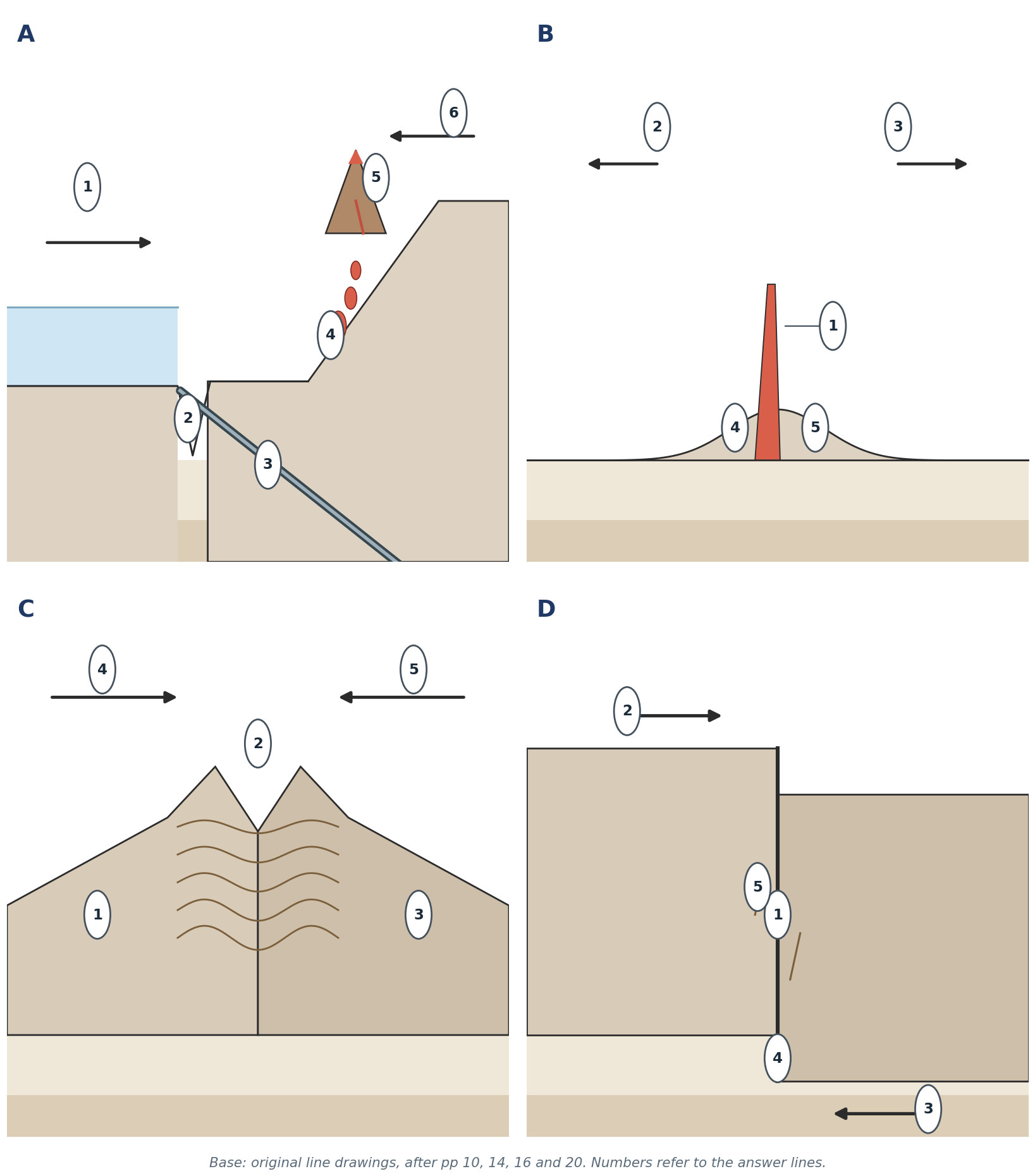
- Convergent boundaries come in three combinations. The key question is: what is on each side? Oceanic + continental → subduction and a volcanic arc. Oceanic + oceanic → island arc. Continental + continental → fold mountains, no arc.
- Cascades 喀斯喀特山脉: the Juan de Fuca Plate subducts eastward under the North American Plate; the volcanoes sit on North America, not on the subducting plate (p 38).
- Transform 转换边界: the San Andreas is where the Pacific Plate slides north-west past North America. Earthquakes — yes; volcanoes — typically no, because no magma is produced (p 53).
- Correction. p 10 lists the San Andreas and Alpine faults as convergence examples. That is wrong. This booklet follows the p 20 / p 53 classification: transform, with typically no volcanism.
"EXAMPLE: WHY NO VOLCANO?" The San Andreas Fault produces frequent earthquakes but no volcanoes. Explain. Answer. It is a transform boundary: the plates slide horizontally past each other. Rock is neither created nor destroyed, and no magma is generated, so there is nothing to erupt. The earthquakes come from friction and sudden slip along the fault. |
"DO NOT CONFUSE" Divergent = apart (new crust, ridges, rifts). Convergent = together (subduction or collision). Transform = past (slip, quakes, no volcanoes). |
Suggested: self-score ☐ ☐ ☐ ☐ ☐ ☐ | / 6 |
CASE 05 Weathering vs erosion 风化与侵蚀:破坏与搬运 |
Term | Key distinction | Do not confuse | Page |
Weathering | Breakdown of rock in place; physical or chemical | Nothing is carried away | pp 17, 19 |
Erosion | Transport of the broken material by an agent | Movement, not just breaking | p 19 |
Freeze–thaw | Water freezes in cracks, expands ~9%, widens them | Needs repeated freeze–thaw | pp 17, 32 |
Thermal / exfoliation | Repeated heating and cooling; outer layers peel | Day–night temperature range | p 32 |
Salt crystallisation | Salt spray → evaporation → crystals push cracks apart | Dry coasts and deserts | p 32 |
Carbonation | CO₂ + rain → weak acid → dissolves calcite in limestone | Chemical, not physical | p 32 |
Agents of erosion | Water/river, wind, glacier, gravity | Agents carry; processes break | pp 30, 53–54 |
Unpack it.
- Weathering 风化 = 原地破坏; erosion 侵蚀 = 搬运走的整个过程. A rock can weather without eroding; it cannot erode without being weathered first (or being picked up whole).
- Physical weathering breaks rock into smaller fragments; chemical weathering changes its composition. 物理风化变碎,化学风化变质。
- Biological weathering 生物风化 can be both: roots widen cracks (physical) and lichens produce acids (chemical).
- River processes (p 30): hydraulic action, abrasion, attrition, corrosion/solution. Agents: water, wind, glacier, gravity. An exam favourite: name the agent, then the process.
- Karst and tors (p 30) are weathering plus removal — the landform appears because the broken material is carried away.
"EXAMPLE: NAME THE PROCESS" A limestone cliff beside a road slowly dissolves where rainwater runs down a joint. A granite tor stands above a slope where the joints are widely spaced. Explain both. Answer. The limestone is weathered by carbonation: rainwater with dissolved CO₂ forms weak carbonic acid, which reacts with calcite and carries away soluble calcium hydrogencarbonate. The tor exists because widely spaced joints slow weathering and removal, so blocks survive while the surrounding rock is removed — weathering plus erosion, not one process alone. |
"CASEY'S CLUE" If the material stays put → weathering. If it moves → erosion. Then name the agent (water, wind, ice, gravity) and the process (abrasion, solution…). |
Suggested: self-score ☐ ☐ ☐ ☐ | / 4 |
CASE 06 Grand Canyon 大峡谷:D–U–D–E 四步 |
Step | What happens | Key word | Page |
D — Deposition | Horizontal layers of sediment build up, usually under water | 沉积 | p 33 |
U — Uplift | Tectonic forces raise the plateau; the river gradient steepens | 抬升 | p 33 |
D — Downcutting | The river cuts vertically into the rising rock | 下切 | p 33 |
E — Erosion | Side valleys, rockfall and runoff widen the canyon | 侵蚀 | p 33 |
Unpack it.
- The order matters: deposition first, because the layers must exist before they can be cut. 先有沉积,再有抬升和下切。
- Uplift does not fold the layers here; they stay roughly horizontal, which is why the canyon walls show flat bands.
- Downcutting happens because uplift steepens the river, giving it more energy to cut down.
- Erosion widens the canyon after the river has cut the slot: side streams, rockfall and rain attack the walls.
- The packet gives no rock names and no ages for the canyon; do not invent them.
"EXAMPLE: SEQUENCE QUESTION" "Why does the Grand Canyon have horizontal layers?" Answer in two sentences using the mnemonic. Answer. The layers were laid down first by deposition in a low, flat environment, so they are horizontal. Uplift raised the whole block without folding it, and the river then downcut through the layers, so the walls expose flat bands. |
Suggested: self-score ☐ ☐ ☐ ☐ | / 4 |
CASE 07 Drainage 水系:河流、湖泊与海洋 |
Feature | Flows to | Note | Page |
Mackenzie River | Arctic Ocean | Longest river flowing to the Arctic in Canada | pp 21, 42 |
Mississippi–Missouri–Ohio | Gulf of Mexico | Drains the interior of the USA | p 21 |
Great Lakes → St Lawrence | Atlantic Ocean | Superior, Michigan, Huron, Erie, Ontario | pp 21, 42 |
Rio Grande | Gulf of Mexico | USA–Mexico border | p 21 |
Colorado River | Gulf of California | Cuts the Grand Canyon | pp 31, 33 |
Hudson Bay | Arctic/Atlantic connection | A bay, not a lake | p 42 |
Unpack it.
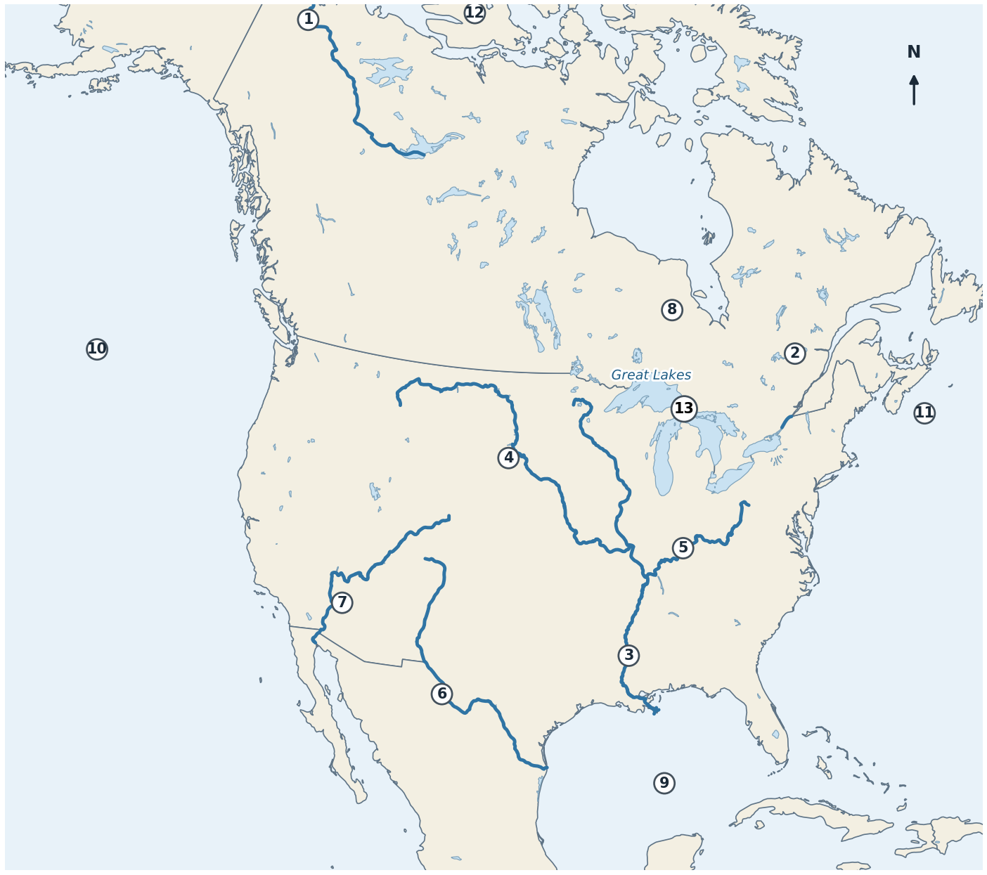
- Three great drainage directions: north to the Arctic (Mackenzie), south to the Gulf of Mexico (Mississippi system, Rio Grande), east to the Atlantic (Great Lakes–St Lawrence).
- The Continental Divide separates Pacific drainage from Atlantic/Arctic drainage (p 31).
- Hudson Bay 哈得孙湾 is a bay, so it is not one of the Great Lakes and not a lake at all.
- The St Lawrence Seaway links the Great Lakes to the Atlantic — a transport route, not a river crossing the continent.
"EXAMPLE: FOLLOW THE WATER" A raindrop falls in northern Alberta. Name two possible routes to the sea. Answer. It could flow north via the Mackenzie system to the Arctic Ocean, or east via the Saskatchewan–Nelson system toward Hudson Bay and the Atlantic. Which one happens depends on which side of the drainage divide it lands. |
Suggested: self-score ☐ ☐ ☐ | / 3 |
CASE 08 Agriculture 农业带:小麦 · 玉米 · 乳牛 |
Belt | Where | Main products | Why there | Page |
Wheat Belt | Kansas → Alberta / Saskatchewan / Manitoba | Spring wheat (Canada), winter wheat (Kansas) | Semi-arid, cool, large flat fields | p 22 |
Corn Belt | Iowa, Illinois, Indiana, Nebraska | Maize, soybeans, pigs, cattle | Deep soils, warm summers, rain | p 22 |
Dairy Belt | Wisconsin, Michigan, New York, Ontario | Milk, cheese, butter | Cool, moist, pasture, near cities | p 22 |
Central Valley | California | Fruit and vegetables | Mild climate, irrigation | p 22 |
Rio Grande Valley | Texas/Mexico border | Citrus | Subtropical warmth | p 22 |
Gulf Coastal Plain | Texas–Florida | Vegetables | Warm, long growing season | p 22 |
Appalachians | Southeast uplands | Cotton, tobacco | Warm season, workable soils | p 22 |
Unpack it.
- The three factors that make farming productive: climate, water, fertile soil (p 23). 气候、水、肥沃土壤。
- The belts are teaching generalisations, not fixed statistical boundaries. Say "approximately" or "the main area".
- Wheat moves from Kansas in the south to Alberta, Saskatchewan and Manitoba in Canada — same crop, different latitude and season. 堪萨斯冬小麦,加拿大大草原春小麦。
- Dairy needs moisture, cool summers and nearby markets because milk is perishable. That is why it is not in hot, dry Kansas.
- Contrast the speciality areas: Central Valley = fruit and vegetables; Rio Grande = citrus; Gulf Coastal Plain = vegetables; Appalachians = cotton and tobacco.
"EXAMPLE: CHOOSE THE BELT" A farmer has deep, level soil, 700 mm of rain a year, warm summers and a rail link to feed mills. Which belt fits, and why? Answer. The Corn Belt: deep soils, reliable rain and warm summers suit maize and soybeans, and the rail link serves feed and livestock. Dairying would need cooler conditions and a nearby city market; wheat would prefer a drier, cooler area further west. |
Suggested: self-score ☐ ☐ ☐ | / 3 |
CASE 09 Dust Bowl 沙尘暴:自然与人为成因 |
Side | Causes | Effect | Page |
Natural | Semi-arid climate, long drought, hot dry winds, light soils | Soil dries and blows | pp 25–26 |
Human | Ploughing grassland, overgrazing, removing vegetation | Bare soil exposed to wind | pp 25–26 |
Result | Dust storms, crop failure, out-migration, health problems | "Dust Bowl" | pp 25–26 |
Spatial point | The worst-drought area is not the same as the Dust Bowl core | Drought was wider | p 52 |
Unpack it.
- Natural + human together: drought alone did not blow the soil away; the soil had already been stripped of the grass that held it. 自然干旱 + 人为破坏植被。
- Cause and effect: drought was a cause; the Dust Bowl was the result. p 26 has this reversed — do not copy it.
- The Dust Bowl core was in the southern/central Great Plains (Texas, Oklahoma, Kansas, Colorado, New Mexico); the drought-affected area was larger (p 52).
- Consequences: topsoil loss, farm foreclosure, migration to California ("Okies"), dust pneumonia.
- Conservation: cover crops, contour ploughing, terracing, shelterbelts, reduced grazing.
"EXAMPLE: FIX THE CAUSALITY" A classmate writes: "The Dust Bowl caused the droughts of the 1930s." Correct the sentence and explain. Answer. "The droughts of the 1930s were one cause of the Dust Bowl." Drought dried the soil; the removal of grassland by ploughing and overgrazing left it exposed; wind then lifted it. The Dust Bowl was the outcome, not the cause. |
Suggested: self-score ☐ ☐ ☐ | / 3 |
Compact block — five small contrasts
Pair | The distinction in one line | Page |
Lithosphere / asthenosphere | Lithosphere = crust + rigid upper mantle (plates); asthenosphere = soft solid that can flow, letting plates move. Use p 34 wording — not "fluid mantle". 岩石圈坚硬,软流圈可缓慢流动 | p 34 |
Large-scale / small-scale map | Large scale (1:10,000) = small area, much detail; small scale (1:10,000,000) = large area, little detail 大比例尺=小范围、多细节 | p 5 |
Cartogram | A map that distorts area in proportion to data (e.g. population) 用面积表示数据 | p 3 |
Rock types | Intrusive igneous = cooled underground, large crystals; extrusive = cooled at the surface, small crystals; sedimentary = compacted/cemented layers, can hold fossils; metamorphic = changed by heat and pressure, not melted 侵入岩结晶大,喷出岩结晶小,沉积岩可含化石,变质岩由热压改变 | p 18 |
Volcano classes vs status | Class = shape/material (cinder, composite, shield); status = activity (active, dormant, extinct). Two separate classifications 火山类型与活动状态是两套分类 | p 58 |
Mount St Helens | Composite volcano in the Cascades, 46°N 122°W, on the North American Plate, above the subducting Juan de Fuca Plate | pp 37–38 |
"CHECK & CORRECT — P10 SAN ANDREAS" p 10 lists the San Andreas Fault as a convergence example. This booklet uses the p 20 / p 53 classification instead: transform, with earthquakes and typically no volcanism. If a question asks you to "correct the statement", this is the correction. |
PART B
Blank practice
Five pages, one skill each. Do them closed-book: cover Part A, then label from memory. Numbers match the answer lines under each figure; the answers are only in the Answer Key at the back.
"SUGGESTED: HOW TO MARK" Use a different colour. A label is only correct if the term and its direction/role are right — "subduction" on a ridge earns nothing. |
PRACTICE 1 Plate boundaries 板块边界:俯冲 · 洋中脊 · 碰撞 · 转换 · no answers on this page |
Label each numbered feature. Say what the plates are doing and name one real example for each panel.
A1. | B2. | C4. |
A2. | B3. | C5. |
A3. | B4. | D1. |
A4. | B5. | D2. |
A5. | C1. | D3. |
A6. | C2. | D4. |
B1. | C3. | D5. |
Suggested: 8 minutes. Write the term, then one arrow direction (e.g. "towards / apart / past").
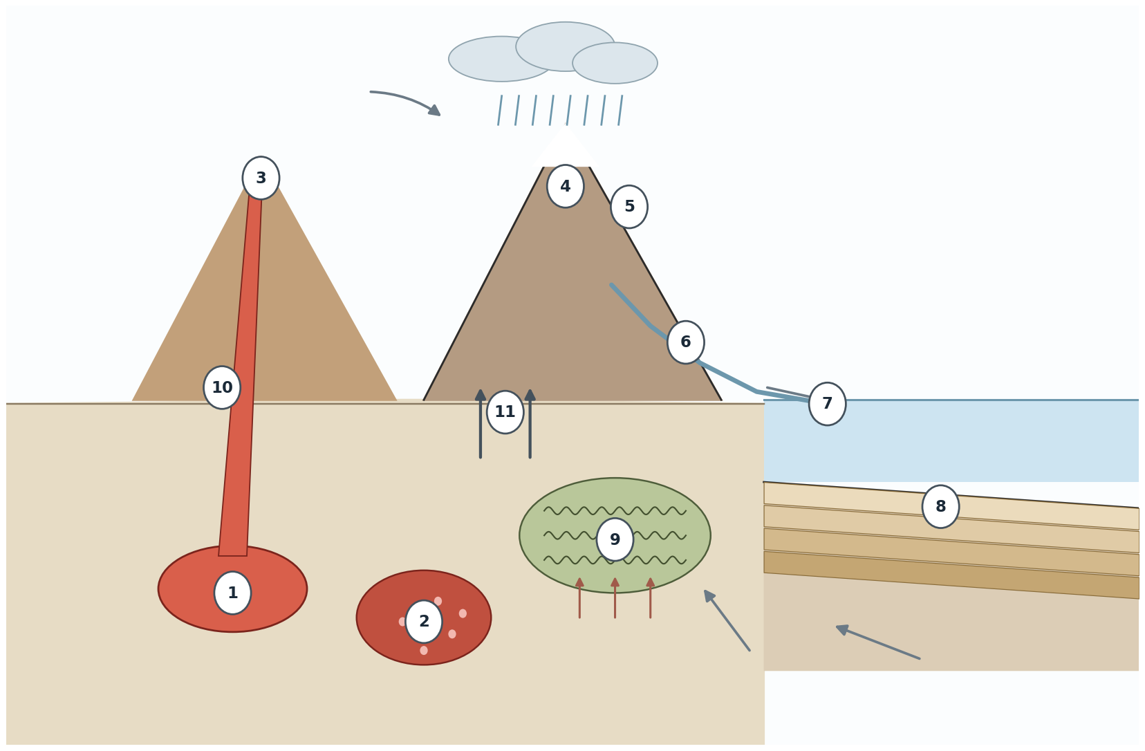
PRACTICE 2 Landscape rock cycle 岩石循环:剖面图填空 · no answers on this page |
Label the numbered processes and rock types. Use the arrows: some show melting, some show uplift, some show transport.
1. | 7. |
2. | 8. |
3. | 9. |
4. | 10. |
5. | 11. |
6. |
Suggested: 7 minutes. For 8, give both parts of the process.
PRACTICE 3 North America waterways 北美水系:河流 · 湖泊 · 海湾 · no answers on this page |
Write the name of each numbered river, lake or water body. Then draw one arrow on each river showing its flow direction.
1. | 6. | 11. |
2. | 7. | 12. |
3. | 8. | 13. |
4. | 9. | |
5. | 10. |
Suggested: 8 minutes. One of these is a bay, not a lake — say which in your answer.
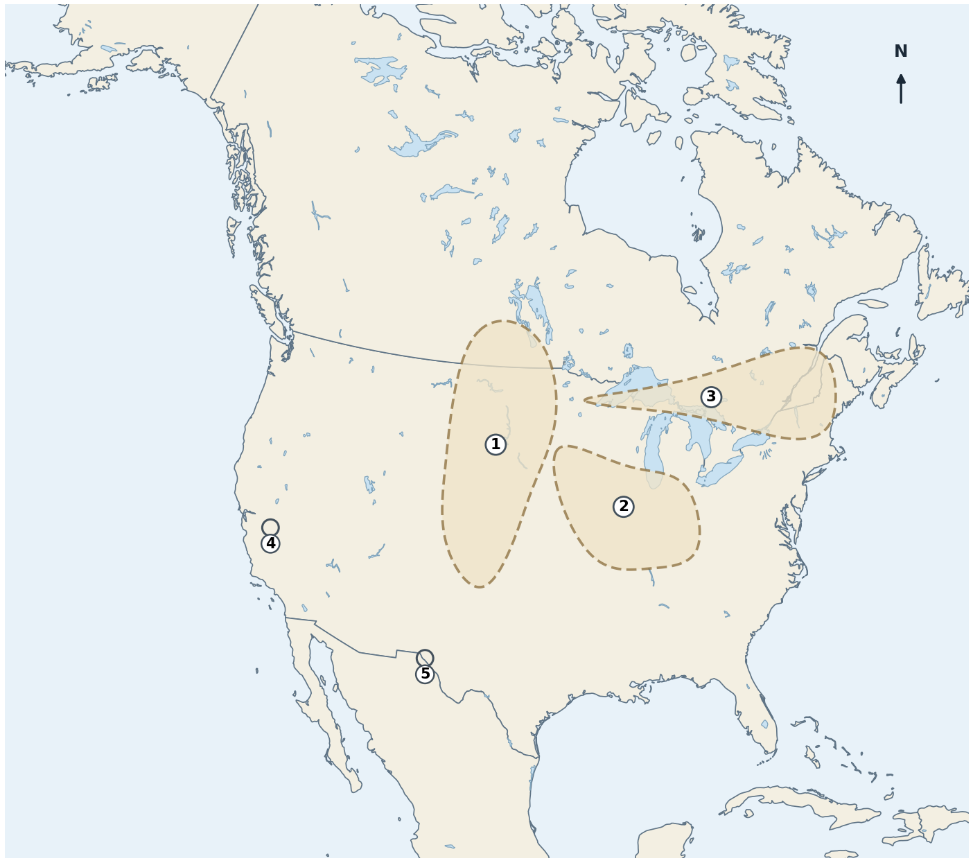
PRACTICE 4 North America agriculture 北美农业带:小麦 · 玉米 · 乳牛 · no answers on this page |
Name belts 1–3. Then name the two speciality areas marked with small circles (4 and 5). Belts are approximate — no fixed borders.
1. | 4. |
2. | 5. |
3. |
Suggested: 6 minutes. For each belt, add one climate or soil reason in the margin.
PRACTICE 5 Earthquake + D–U–D–E 地震构造与大峡谷四步 · no answers on this page |
Label 1–4 on the earthquake diagram. Then fill the four boxes below the figure with the D–U–D–E stages of the Grand Canyon, in order.
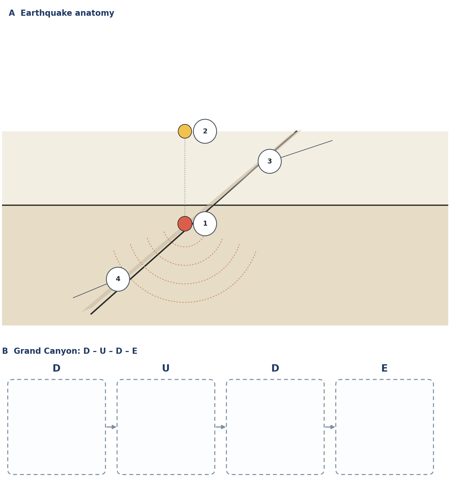
1. | 3. |
2. | 4. |
Suggested: 6 minutes. In box B, write the order letters and one verb for each stage.