PART A / CASE 01
Geo Detective Lab
Confusable terms + draw-from-memory practice | 易混对照与默画
Suggested: Meet Pip Field, our original young field detective. Solve one small case at a time.
| Suggested: Pip Field’s clue / 小侦探提示 |

Source guide: p60 means PDF page 60 of the classroom packet 习题.pdf. Facts follow the supplied coverage inventory; “Suggested:” marks added teaching prompts and examples.
Space → atmosphere → ground
Term / 术语 | Key distinction / 关键区别 | Do not confuse / 易混点 | |
|---|---|---|---|
Meteoroid | A small rock or metal body travelling in space. / 太空中的小岩石或金属体 | The object before the atmospheric light event. | p60 |
Meteor | The luminous streak seen in the atmosphere. / 大气中的发光轨迹 | The streak, not the surviving ground fragment. | p60 |
Meteorite | The fragment that survives and reaches the ground. / 到达地面的残片 | Use the ground-survival clue. | p60 |
Comet | An icy, dusty body associated with a tail. | Not another name for a meteor. No tail-direction rule is tested here. | p60 |
Suggested: Worked example / 例解 — “A metal fragment is still in space.” → meteoroid. “A bright streak appears in the atmosphere.” → meteor. “A fragment survives on the ground.” → meteorite. The location or phenomenon changes the term. (p60)
Suggested: Worked example / 例解 — “An icy, dusty body with a tail” → comet, not meteor. Ice/dust is the distinguishing clue. (p60)
Suggested: Self-check □ explain it □ need a retest Score: ______
PART A / CASE 02
Shaking ground & volcanoes
Separate the point, the instrument and the scale. / 点、仪器、量度分开记
Term / 术语 | Key distinction / 关键区别 | Do not confuse / 易混点 | |
|---|---|---|---|
Focus | Underground point where earthquake energy is released. | Not the point on the surface. | p59 |
Epicentre | Surface point directly above the focus. | “Above” does not mean the same point. | p59 |
Seismograph | Instrument that records seismic waves. | An instrument, not a location or scale. | p58–59 |
Richter | Measures earthquake magnitude. | Magnitude is not the observed effects at a place. | p58 |
Mercalli | Describes observed earthquake effects. | Effects, not the recording instrument. | p58 |
Suggested: Worked example / 例解 — “The underground release point” → focus; “directly above it at the surface” → epicentre. “Records the waves” → seismograph; “magnitude” → Richter; “observed effects” → Mercalli. (p58–59)
Volcano shape ≠ volcano status
Term / 术语 | Key distinction / 关键区别 | Do not confuse / 易混点 | |
|---|---|---|---|
Cinder / Composite / Shield | Shape/material classification: distinguish the cone forms in the packet. | These names do not state whether the volcano is active now. | p58 |
Active / Dormant / Extinct | Activity-status classification, separate from shape. | Do not match one shape to one status. No fixed-year cut-offs are added. | p58 |
Mount St Helens | Composite volcano in the Cascades; classroom absolute location: 46°N 122°W. | Its type, region and coordinates answer different questions. | p37–38 |
Suggested: Worked example / 例解 — “Which type is Mount St Helens?” → composite. “Where?” → Cascades; 46°N 122°W. (p37–38)
Suggested: Self-check □ explain it □ need a retest Score: ______
PART A / CASE 03
Which way do the plates move?
Divergent = apart 分离 • Convergent = together 汇聚 • Transform = slide past 错动
Term / 术语 | Key distinction / 关键区别 | Do not confuse / 易混点 | |
|---|---|---|---|
Oceanic divergence | Mid-Atlantic Ridge: ridge, new seafloor, volcanism and shallow earthquakes. | Do not use the conflicting motion answer on p20; follow p14. | p14 |
Continental divergence | East African Rift: rift and normal faults; shallow earthquakes and volcanism. | A continental rift is not an oceanic subduction trench. | p14 |
Oceanic–continental convergence | Cascades: Juan de Fuca beneath North America. Andes is another packet example. | The subducting plate and the continent carrying the volcanic line are not the same. | p16, |
Oceanic–oceanic convergence | Japan / Aleutians / East Caribbean: subduction, earthquakes and an island chain. | Do not replace “island chain” with continental collision. | p16 |
Continental–continental convergence | Compression causes folding/faulting, mountain-building, crust shortening and thickening; shallow earthquakes. | Do not use San Andreas as the example. | p10 |
Transform | San Andreas: plates slide past; earthquakes, typically no volcanism. | Not convergence. The “normally” qualifier matters. | p10, |
Packet correction / 讲义更正: p10 lists San Andreas in a convergence-example line. Use the transform classification corroborated by p20 and the no-volcanism exam scope on p53.
Suggested: Worked example / 例解 — A cross-section shows Juan de Fuca descending beneath North America with a continental volcanic line. → oceanic–continental convergence, the Cascades case. (p16, p37–38)
| Suggested: Pip Field’s clue / 小侦探提示 |

Suggested: Self-check □ explain it □ need a retest Score: ______
PART A / CASE 04
Break down, change — or move?
Weathering 风化 changes/breaks rock; erosion 侵蚀 transports material. (p19)
Term / 术语 | Key distinction / 关键区别 | Do not confuse / 易混点 | |
|---|---|---|---|
Freeze–thaw | Water enters cracks → freezes and expands → repeated action breaks rock. | A weathering process, not an erosion agent. | p17 |
Thermal / exfoliation | Heating/cooling → different expansion and contraction → stress and exfoliation in the packet sequence. | Not salt-crystal growth. Do not assume every exfoliation has this cause. | p32 |
Salt crystallisation | Saltwater → evaporation → crystals exert pressure in cracks. | Crystal growth, not freezing water. | p32 |
Carbonation | CO₂ + rain → weak carbonic acid; reaction with calcite produces soluble material removed by water. | Chemical change, not just physical breakage. | p32 |
Biological weathering | Organisms can cause mechanical and chemical weathering. | Plants belong with weathering in the packet grouping. | p30, |
Agents of erosion | Wind, gravity, glaciers and river/water move material. | An agent is what does the moving; a process describes what happens. | p30, |
River processes | Hydraulic action, abrasion, attrition and corrosion are packet process names. | Do not put process names in the agents list. | p30 |
Suggested: Worked example / 例解 — Water freezes in a crack → freeze–thaw weathering. Wind then carries loose material away → wind is an agent of erosion. First ask “break/change or move?” (p17, p19, p30)
Suggested: Worked example / 例解 — A root acts on rock → biological weathering; a glacier moves material → agent of erosion. This explains the grouping, rather than memorising the two lists without a reason. (p30, p54)
Suggested: Self-check □ explain it □ need a retest Score: ______
PART A / CASE 05
Rocks & the moving outer shell
Formation process first; then the rock name. / 先看形成过程,再判断类别
Term / 术语 | Key distinction / 关键区别 | Do not confuse / 易混点 | |
|---|---|---|---|
Intrusive igneous | Magma cools underground; packet diagram contrasts larger crystals with extrusive cooling. | Underground magma, not surface lava. | p18 |
Extrusive igneous | Lava cools at the surface; the packet contrasts smaller crystals. Obsidian is an igneous example. | Do not put every igneous example in the intrusive group. | p18 |
Sedimentary | Sediment accumulates in layers; compaction and mineral cement bind it. Examples: chalk, sandstone, shale, banded iron. | Not rock changed by heat and pressure. | p18 |
Metamorphic | Existing rock is changed by heat and pressure, including magma-contact effects. Examples: marble, slate, gneiss. | Melting is a different step in the rock cycle. | p17–18, |
Suggested: Worked example / 例解 — Sediment becomes compacted and cemented → sedimentary. Heat and pressure change rock → metamorphic. Melting leads back towards magma; do not label melting “compaction”. (p17–18, p39)
Lithosphere vs asthenosphere
Term / 术语 | Key distinction / 关键区别 | Do not confuse / 易混点 | |
|---|---|---|---|
Lithosphere | Crust + rigid upper mantle. / 地壳+刚性上地幔 | It is not the crust alone. | p34 |
Asthenosphere | Soft solid capable of movement beneath the lithosphere. / 能缓慢运动的柔软固态 | “Soft” does not mean a liquid upper mantle. | p34 |
Suggested: Worked example / 例解 — “Crust plus rigid upper mantle” → lithosphere. “Soft solid capable of movement” → asthenosphere. Use p34, not p65’s conflicting “fluid” wording. (p34)
| Suggested: Pip Field’s clue / 小侦探提示 |

Suggested: Self-check □ explain it □ need a retest Score: ______
PART A / CASE 06
Follow the water; order the canyon
A river route is not a list of nearby names. / 河流要连着流向一起记
Term / 术语 | Key distinction / 关键区别 | Do not confuse / 易混点 | |
|---|---|---|---|
Mackenzie | Drains to the Arctic Ocean. / 流向北冰洋 | Do not attach it to the Mississippi system. | p21 |
Mississippi–Missouri–Ohio | Connected drainage system leading to the Gulf of Mexico. / 墨西哥湾 | Not the Great Lakes–St Lawrence route. | p21 |
Great Lakes–St Lawrence | The packet’s connected waterway route. / 五大湖—圣劳伦斯水道 | Do not substitute the Mississippi system. | p21 |
Hudson Bay | A bay, not a lake. | Its name is not one of the Great Lakes. | p36, |
Suggested: Worked example / 例解 — “Which river drains to the Arctic?” → Mackenzie. “Which linked system reaches the Gulf of Mexico?” → Mississippi–Missouri–Ohio. Answer the route, not just the continent. (p21)
Map label set: Mackenzie, St Lawrence, Mississippi, Missouri, Ohio, Rio Grande, Colorado; Arctic, Pacific, Atlantic, Gulf of Mexico and Hudson Bay. (p21, p31, p36, p42)
Grand Canyon: D–U–D–E
Term / 术语 | Key distinction / 关键区别 | Do not confuse / 易混点 | |
|---|---|---|---|
1 · D | Deposition / 沉积 | First D: material is deposited. | p33 |
2 · U | Uplift / 抬升 | Uplift comes before downcutting in this mnemonic. | p33 |
3 · D | Downcutting / 下切 | Second D: downcutting, not deposition again. | p33 |
4 · E | Erosion / 侵蚀 | Keep the packet’s final E after downcutting. | p33 |
Suggested: Worked example / 例解 — “D–U–D–E” → deposition → uplift → downcutting → erosion. Say both D words in full; the repeated initial is the trap. No geological ages or missing rock names are supplied. (p33)
Suggested: Self-check □ explain it □ need a retest Score: ______
PART A / CASE 07
Belts, crop regions & the Dust Bowl
A named belt is not every place where that crop is grown. / 农业带不等于所有同类产区
Term / 术语 | Key distinction / 关键区别 | Do not confuse / 易混点 | |
|---|---|---|---|
Wheat Belt | Kansas → Alberta, Saskatchewan and Manitoba. | Learn the cross-border route, not just “central North America”. | p22 |
Corn Belt / Dairy Belt | Separate named agricultural belts in the packet map. | Do not swap their product labels. Map shading is schematic, not a fixed boundary. | p22–23 |
Central Valley | Fruit and vegetables / 水果、蔬菜 | Not the Wheat Belt label. | p22 |
Rio Grande region | Citrus / 柑橘 | Not the Central Valley fruit/vegetable label. | p22 |
Gulf Coastal Plain | Vegetables / 蔬菜 | Keep this association distinct from the Rio Grande citrus case. | p22 |
Appalachians | Cotton and tobacco / 棉花、烟草, in this packet association. | A classroom association, not a claim that every place grows only these crops. | p22 |
Productive agriculture | Climate + water + fertile soil / 气候、水、肥沃土壤 | One factor alone is not the packet’s complete answer. | p23 |
Suggested: Worked example / 例解 — “Kansas into Alberta/Saskatchewan/Manitoba” → Wheat Belt; “Central Valley crops” → fruit/vegetables. To explain productivity, give climate, water and fertile soil together. (p22–23)
Dust Bowl: natural + human causes
Natural / 自然: semi-arid climate (半干旱气候) and drought (干旱). Human / 人为: ploughing and grazing remove vegetation (翻耕、放牧移除植被). Use the combined explanation, not drought alone. (p25–26)
Spatial trap / 区域陷阱: the worst-1930s-drought area is not the same as the Dust Bowl region. (p52)
Suggested: Worked example / 例解 — “It was only natural” is incomplete: add the vegetation removal caused by ploughing/grazing. Do not repeat the reversed statement that the Dust Bowl caused drought. (p25–26, p52)
Suggested: Self-check □ explain it □ need a retest Score: ______
PART A / CASE 08
Regions & map choices
Choose the criterion before choosing the label. / 先看判断依据
Term / 术语 | Key distinction / 关键区别 | Do not confuse / 易混点 | |
|---|---|---|---|
Formal region | Shared defining characteristics / 共同特征. Packet example: Latin America as a formal cultural region. | Not defined by a central node and its connections. | p4, |
Functional region | Organised around a node and connections: node-and-spokes. / 中心节点与联系 | Connections/function, not simply shared perceptions. | p4 |
Perceptual region | Shared subjective images / 共同主观印象. Packet examples: South and Midwest. | Perceptions need not give a single sharply fixed boundary. | p1 |
Suggested: Worked example / 例解 — “Latin America as a cultural region” → formal. “A node linked to surrounding spokes” → functional. “Shared images of the South/Midwest” → perceptual. Explain the criterion, not just the name. (p1, p4, p44)
No type is assigned here to the ambiguously placed p55 examples such as Silicon Valley.
Scale & cartograms
Term / 术语 | Key distinction / 关键区别 | Do not confuse / 易混点 | |
|---|---|---|---|
Large-scale | Smaller area, more detail. / 范围小,细节多 | “Large” refers to scale, not a larger area shown. | p5 |
Small-scale | Larger area, less detail. / 范围大,细节少 | Do not reverse area and detail. | p5 |
Cartogram | Area/size is made proportional to data. / 大小按数据调整 | Not an ordinary map preserving geographic area. | p3 |
Suggested: Worked example / 例解 — Need more detail of a smaller area? → large-scale. Need a broader area with less detail? → small-scale. If mapped sizes are proportional to data, identify a cartogram. (p3, p5)
| Suggested: Pip Field’s clue / 小侦探提示 |

Suggested: Self-check □ explain it □ need a retest Score: ______
PART B / BLANK PRACTICE 01
Plate-boundary evidence
Suggested: Name each boundary and its packet example. Fill P1–P12; add your own movement arrows.
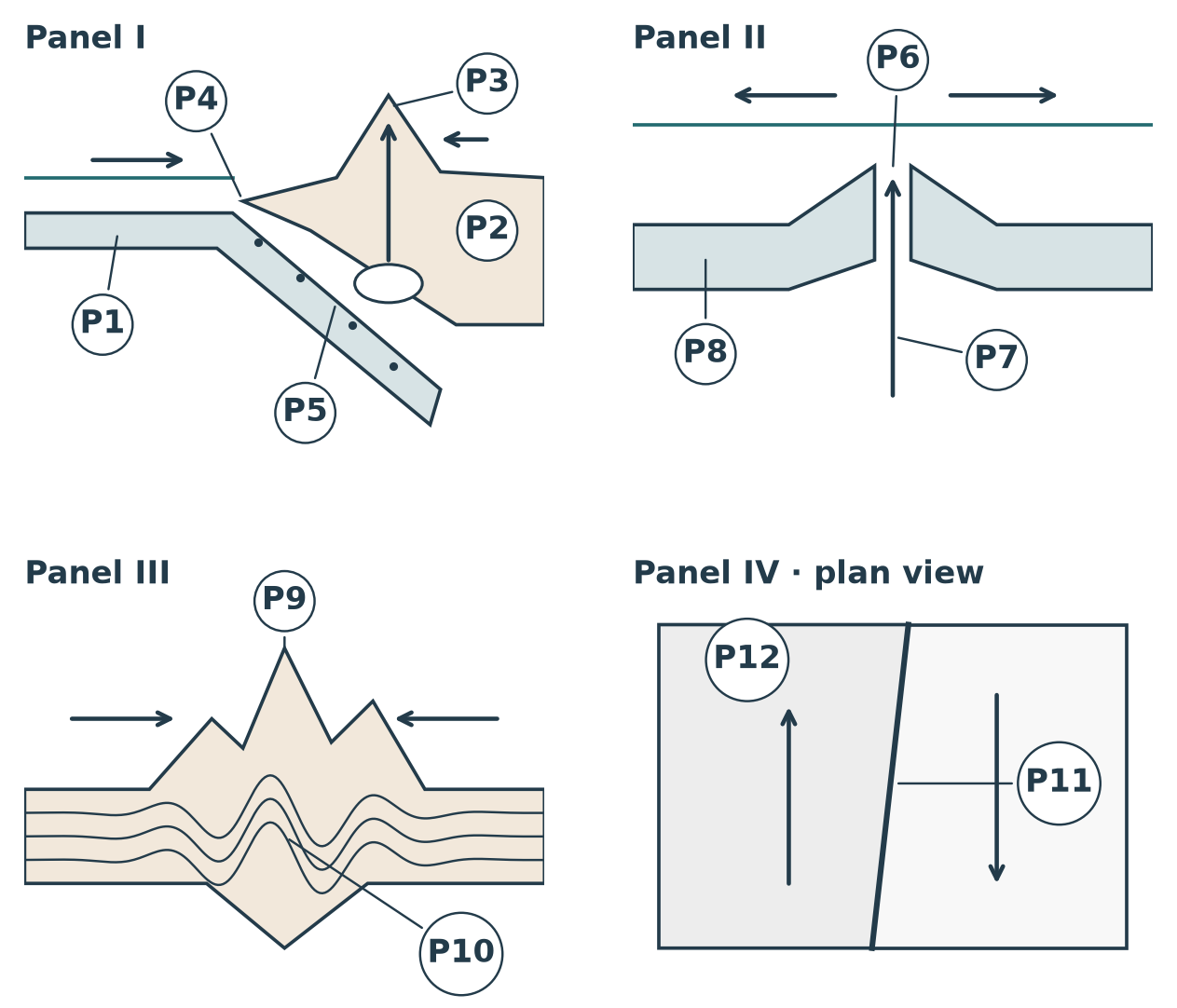
I: type + example _____________________________ | II: type + example _____________________________ |
III: type _____________________________ | IV: type + example _____________________________ |
P1 _________________ | P2 _________________ | P3 _________________ |
P4 _________________ | P5 _________________ | P6 _________________ |
P7 _________________ | P8 _________________ | P9 _________________ |
P10 _________________ | P11 _________________ | P12 _________________ |
Suggested: Redraw the most difficult panel on scrap paper without looking. □ retest
PART B / BLANK PRACTICE 02
One landscape, many rock pathways
Suggested: Fill the numbered features/processes. Trace a complete surface-to-depth pathway, then redraw it.
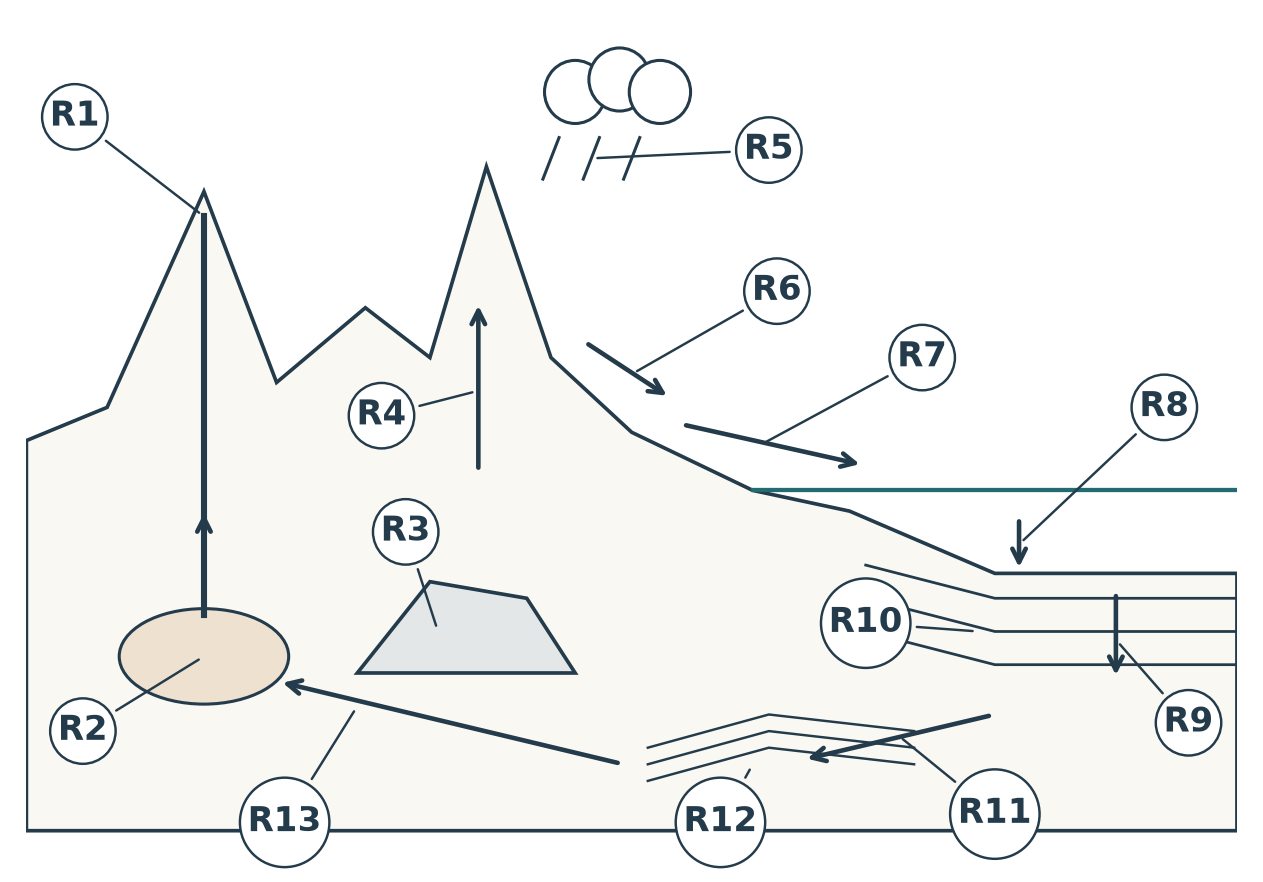
R1 _____________________________ | R2 _____________________________ |
R3 _____________________________ | R4 _____________________________ |
R5 _____________________________ | R6 _____________________________ |
R7 _____________________________ | R8 _____________________________ |
R9 _____________________________ | R10 _____________________________ |
R11 _____________________________ | R12 _____________________________ |
R13 _____________________________ |
Suggested: Explain a route in your own words: __________________________________
____________________________________________________________________
PART B / BLANK PRACTICE 03
North America: waterways
Suggested: Name W1–W12. Add arrows showing the drainage routes you can recall. No word bank.
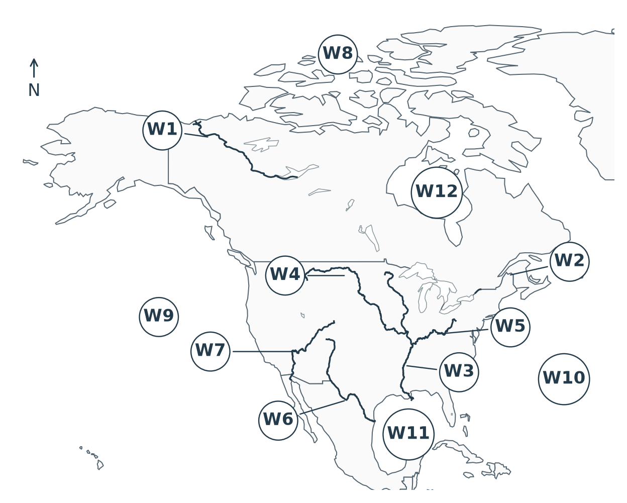
W1 _____________________________ | W2 _____________________________ |
W3 _____________________________ | W4 _____________________________ |
W5 _____________________________ | W6 _____________________________ |
W7 _____________________________ | W8 _____________________________ |
W9 _____________________________ | W10 _____________________________ |
W11 _____________________________ | W12 _____________________________ |
Suggested: Write the connected routes: ________________________________________
____________________________________________________________________
Base geometry: Natural Earth, public domain. Classroom label set: p21, p31, p36, p42. Geographic sketch; not for measurement.
PART B / BLANK PRACTICE 04
North America: agriculture
Suggested: Name the three schematic belts A1–A3 and route anchors A4–A7. Hatching is not a precise boundary.
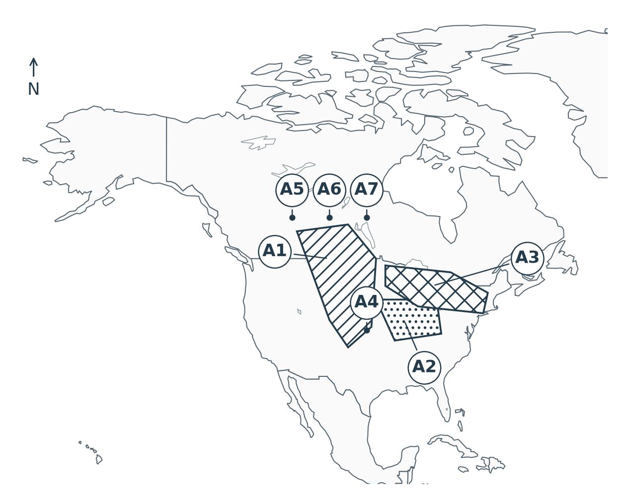
A1 _____________________________ | A2 _____________________________ |
A3 _____________________________ | A4 _____________________________ |
A5 _____________________________ | A6 _____________________________ |
A7 _____________________________ |
Suggested: List the three productive-agriculture factors:
1. __________________ 2. __________________ 3. __________________
Suggested: On another copy, hide the hatching and redraw the belts from memory. □ retest
Base: Natural Earth, public domain. Suggested schematic belt overlay: classroom associations p22–23, not surveyed extents.
PART B / BLANK PRACTICE 05
Earthquake + four-step recall
Suggested: Fill E1–E4. Then complete the four boxes in order, without turning to the answer key.
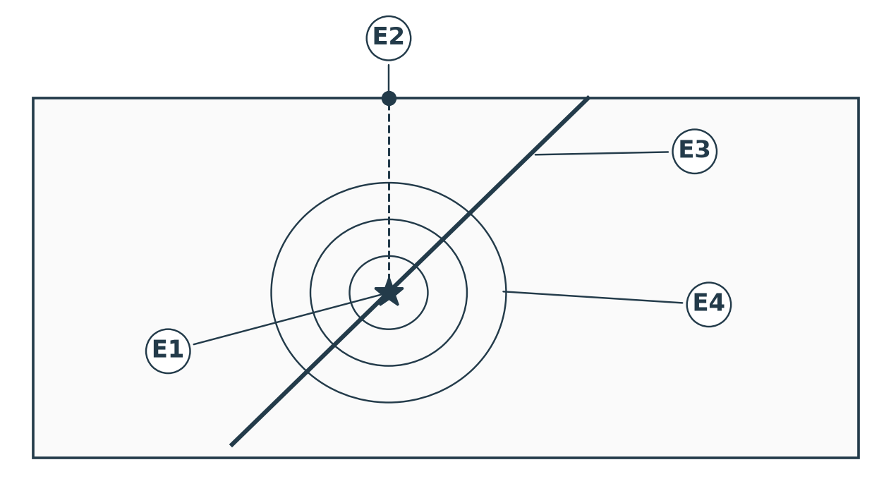
E1 _____________________________ | E2 _____________________________ |
E3 _____________________________ | E4 _____________________________ |
D–U–D–E
D1 | D2 | D3 | D4 |
Suggested: Say why the two D words are different: ______________________________
____________________________________________________________________
Suggested: Stop here. Finish all labels before opening the detached key. □ done
SUGGESTED / RETEST LOG
Keep the key closed
Suggested: This page deliberately contains no answers. It protects the last practice page when printing double-sided.
| Suggested: Pip Field’s clue / 小侦探提示 |

Case / item ID _____________________________ | Case / item ID _____________________________ |
Case / item ID _____________________________ | Case / item ID _____________________________ |
Case / item ID _____________________________ | Case / item ID _____________________________ |
Suggested: My next recall attempt / 下次回忆自测
____________________________________________________________________
____________________________________________________________________
____________________________________________________________________
Suggested: The detachable answer section begins on the next sheet. Remove it before practice.